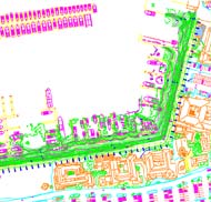
The topographic map is one of the most widely used types of maps. One can distinguish a topographic map from other kinds of maps by observing the use of contour lines to portray the nature and outline of the land. These maps delineate the three-dimensional details of the topography on a two-dimensional surface.
Topographic maps are known to depict both man-made and natural features. They outline various geographical features like mountains, valleys, plains and vegetation. They also help in recognizing chief man-made features like roads, transmission lines and buildings.
Topographic maps provide an extensive information base for experts and layman alike. They are used mostly for engineering, energy research, natural resource preservation, commercial and residential development and for various outdoor activities.
Topographic mapping is vital for a wide range of applications, including:
- emergency and disaster response,
- national defense,
- asset and facilities management,
- demographics analysis,
- environmental monitoring,
- mineral and energy exploration,
- fleet and logistics management,
- graphic presentation of thematic data,
- infrastructure planning,
- other map production,
- market analysis, navigation and positioning,
- route planning,
- risk assessment,
- surveillance, and
- Teaching
These maps are used by construction, architectural or other related companies to study the land and its various topographies before the actual construction starts.
Our topographic mapping service offers you an effective topographic mapping solution. To get started please upload your request for proposal to get a quote for your project.